


La Boissière circuit voie ferrée

kephas
User
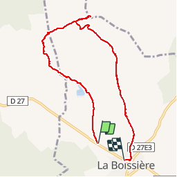

Length
8.4 km

Max alt
219 m

Uphill gradient
101 m
Km-Effort
9.7 km

Min alt
142 m

Downhill gradient
79 m
Boucle
No
Creation date :
2019-05-07 03:09:11.447
Updated on :
2019-05-07 03:09:11.447
3h18
Difficulty : Very easy

FREE GPS app for hiking
 SityTrail
IGN / Geographical institutes
SityTrail Plus
The world is yours!
About
Trail Other activity of 8.4 km to be discovered at Occitania, Hérault, La Boissière. This trail is proposed by kephas.
Description
Bonnes pistes bien que caillouteuses en 1ère partie sur l'ancienne voie ferrée : peu d'ombre de bout en bout, à privilégier l'hiver.
Photos


Positioning
Country:
France
Region :
Occitania
Department/Province :
Hérault
Municipality :
La Boissière
Location:
Unknown
Start:(Dec)
Start:(UTM)
551358 ; 4835157 (31T) N.
Comments